
內容簡介
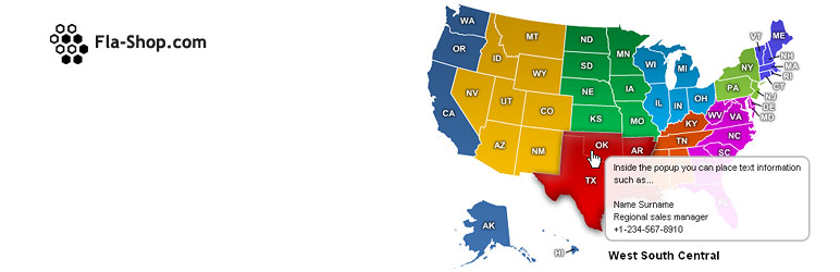
使用這個免費的美國互動地圖外掛程式,您可以輕鬆地在不同的顏色區域中顯示互動式美國地圖區域。它允許您添加可點擊的美國地圖,當用戶點擊地圖上的特定區域時,可以打開一個URL或顯示更多信息。
需要一個帶有州的互動式美國地圖嗎?請查看我們的網站用互動式美國地圖。
此免費外掛程式允許您使用豐富的視覺或文本編輯器添加內容,以展示不同目的的信息,例如分支/經銷商網絡、銷售區域和交付位置。您還可以使用它製作互動式信息圖和以提示語呈現統計數據,從而以更引人入勝的方式呈現。
此外掛程式使您的美國地圖看起來非常出色。
免費外掛程式中的所有基本功能:
- 可點擊的區域。
- 響應式和適用於移動設備。
- 創建無限地圖。
- 工具提示。
- 基於SVG。
- 適用於iOS/Android設備。
- 通過短碼進行簡單的嵌入。
- 簡單的安裝。
- 不同的內置地圖自定義功能。
- 通過WordPress儲存庫提供優秀支持。
付費版本中可獲得的所有功能:
- 可點擊的州。
- 地圖上的標記。
- 設置自己的區域。
- 與Popup Builder、TablePress和其他外掛程式集成。
- 自定義顏色,平滑切換顏色。
- 可自定義字體。
- 可自定義的點擊操作,包括鏈接、彈出窗口等。
- 每個州的單獨和批量設置。
- 批量編輯。
- 通過CSV表格導出/導入設置。
- 沒有品牌鏈接。
- 24/7支持。
現在試試互動式美國地圖外掛程式!
更多有關免費互動式美國地圖的資訊:
此外掛程式為您提供許多直觀的控制,以自定義互動式地圖,以滿足不同場合的需求。無論是區域的顏色、添加鏈接、內容、在工具提示中顯示信息,甚至隱藏某些區域,此外掛程式為您提供了所有基本控制。
因此,您可以自由創建不同類型的無限互動式美國地圖,而無需尋找另一個WordPress互動式地圖外掛程式。
此外,這個外掛程式的有趣之處在於,您無需具備任何編碼知識或技能即可充分使用它。如果您擁有一些CSS和JS技能,則可以進一步增強互動式美國地圖的功能。通過自定義互動式地圖功能,令人興奮的是,您無需訪問放置地圖短碼的頁面即可查看更改。相反,您可以使用預覽選項卡在創建新互動式美國地圖時即時查看變更。
但這並非本免費的美國互動地圖外掛程式所提供的全部內容;還有更多。
地圖設置
在外掛程式的地圖設置中,您可以自定義整個地圖的佈局和功能,以滿足您的需求。
- 單擊即可創建響應式或非響應式的地圖。
- 定義自定義寬度和高度。
- 顯示區域名稱列表。
- 定義列表的自定義寬度和字體大小。
- 使列表成為移動設備和移動和桌面雙重使用的下拉列表。
- 標記工具提示
外掛標籤
開發者團隊
② 後台搜尋「Interactive US Map – Create Clickable & Customizable U.S. Maps」→ 直接安裝(推薦)
原文外掛簡介
Using this free USA interactive map plugin for WordPress, you can easily display interactive US maps regions in different colors. It allows you to add a clickable US map that can open a URL or display more information when users click on a particular area of the map.
Looking for an Interactive US Map With States? Check Out Our US Interactive Map for Websites.
This free plugin allows you to use the rich visual or text editor to add the content to show information for different purposes. For example, branch/dealer network, sales regions, and delivery locations. You may also use it to make interactive infographics and present statistical data in a much engaging way with a tooltip on hover.
The plugin makes your interactive map of the United States look outstanding.
All the Essential Features Available in the Free Plugin
Clickable regions.
Responsive and mobile-friendly.
Create unlimited maps.
Tooltips.
SVG based.
Works on iOS/Android devices.
Easy embedding by a shortcode.
Simple installation.
Different multiple built-in features for map customization.
Outstanding support through WordPress repository whenever you need it.
What You Get With the Premium Version
Clickable states.
Markers on the map.
Set up your own regions.
Integration with Popup Builder, TablePress, and others.
Color customizing, smooth change color.
Customizable fonts.
Customizable click actions – links, pop-ups, and more.
Individual and batch settings for states.
Bulk editing.
Export/import settings via CSV tables.
No brand link.
24/7 Support.
Try Interactive USA Map for WordPress now!
More Information on Free Interactive Us Map
This plugin provides you with many intuitive controls to customize the interactive map for different occasions. Whether it’s the region’s color, adding links, content, showing info in the tooltip, or even hiding some of the regions, the plugin gives you all the essential controls.
So, you can freely create different kinds of unlimited interactive US maps without looking for another WordPress interactive map plugin.
In addition, the interesting thing about this plugin is that you don’t need to have any coding knowledge or skills to use it to its fullest. And if you’ve got some CSS and JS skills, you can enhance the functionality of the interactive US map even more. With custom interactive map capability, what’s thrilling is that you don’t have to visit the page to view changes where the map’s shortcode is placed. Instead, you can use the Preview tab to view changes at the exact moment you’re creating a new interactive US map.
But that’s not all this free US interactive map plugin has to offer; there’s more to it.
Map Settings
Under the Map Settings of the plugin, you can customize the overall map’s layout and functionalities to utilize it per requirements.
Create the map responsive or unresponsive with a single click.
Define custom width & height.
Show a list of regions’ names.
Define custom width & font size for the list.
Make the list a Dropdown for mobile and both mobile & desktop.
Pin tooltip on click.
Enable shadows, border color, and a lot more.
General Content Settings
Want to add information about the interactive map that gets displayed by default? You can use the Content Info section in the General settings tab that provides you with a rich visual & text editor to do that easily. Further, it allows to
Place the map’s information at the bottom or right side.
Apply automatic scroll to information.
Add images and use the editor to its fullest with HTML tags and more.
Colors & Map Typography
Make your interactive US map color look engaging with elegant typography and other visual customizations such as,
Separate font family, size, and color options for regions’ names & tooltip.
Apply stroke on regions’ names with different colors on hover.
Use custom width and opacity for strokes.
And define separate font family, color, and size for Tooltip Comment.
Region Controls
The Detailed setting available with the plugin allows you to customize individual regions and add information about them.
The controls make you run Bulk Edit.
Define regions’ short and long names.
Controls to hide complete name on hover.
Multiple map click options – Open a URL, Show More Info, and Nothing.
Use Visual or Text editor to add information with an image.
Display information On-Click or Hover.
Apply regions’ background color (By default and On-hover.)
Hide area, use custom CSS, and more.
Performance Options
Load every page faster and without any technical issues that contain the interactive US map using the options available in the Performance setting.
Enable setting caching.
Minimize code output.
Delay JS output.
Additional Features of the Free Interactive US Map Plugin
In addition to the above high-performing features, the plugin also includes some other crucial controls that complete the plugin in all the senses. Features like,
Exporting and importing map settings for backup or transferring to another site.
Use additional JavaScript.
And many other useful options to utilize the plugin at its best.
Want to Create an Editable US Map With States? Try Our U.S. Interactive Map for Websites
If you want to display a USA interactive map with all the states, then using the premium US interactive map plugin, you can do that easily. Its intuitive options allow you to add and display all the 50 states on a single interactive map in no time.
Like the free editable US map plugin, you can use the premium version to showcase the clickable US map having each state in a different color. You get all the features of the free plugin and other highly-efficient features to improve the map’s functionality.
Some of the additional features the premium plugin offer are as follows,
Create zoomable maps.
Create states’ groups with additional customization options.
Show Lightbox Popup when users click on the map area.
Display location highlighter or marker in different shapes – Point, Star, Marker, and Transparent.
Add links, tooltips, and information next to the map for markers.
Apply global or individual customization to the marker like color, size, font family, and more.
Check it out today to find out more.
What Our Users Think of These Plugins
“Very kind Support and helpfully. Very nice products. Thank you” ~Denis Ibra
“Great customer support and instant solutions for my random questions about custom features. Been using their maps for a long time and highly recommend them!” ~Joe Timmons
“I have tried so many maps and THIS IS THE ONLY ONE I HAVE FOUND THAT DOES EVERYTHING I WANT IT TO — AND IS SO EASY TO USE. Thanks…” ~Jamie Talan