內容簡介
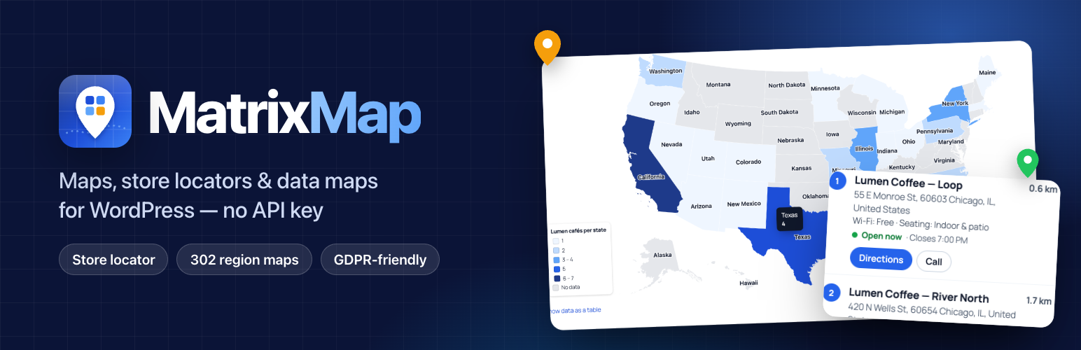
MatrixMap 是一款讓您在網站上輕鬆嵌入地圖的外掛,無需 API 金鑰或帳戶,並且不會產生月費。它提供視覺編輯器來建立地圖,並支援商店定位器功能,讓訪客能夠快速找到最近的地點。
【主要功能】
• 無需 API 金鑰,立即啟用地圖功能
• 支援商店定位器,無限制地點數量
• 提供 302 個區域地圖,包含所有美國縣
• 具備鍵盤與螢幕閱讀器支援
• 可從其他外掛輕鬆轉移地圖與商店資料
外掛標籤
開發者團隊
② 後台搜尋「MatrixMap – Google Maps, OpenStreetMap, Store Locator & World Maps」→ 直接安裝(推薦)
📦 歷史版本下載
原文外掛簡介
Live demo | Website | Features | Free vs Pro | MatrixMap Pro | Pricing | FAQ | Documentation | Support
MatrixMap puts maps on your site in minutes, with no API key, no account and no monthly bill. Build a map with a visual editor, add a store locator that finds the nearest locations, or colour a world or country map with your own data. Everything is keyboard and screen reader accessible, and nothing loads until a visitor needs it. See it on the MatrixMap website or try the live demo right in your browser.
Why MatrixMap?
Free where others charge: the store locator, 302 region maps (including every US county), CSV import and plugin importers are all in the free plugin, with no limits on maps, places or locations and no MatrixMap branding on your maps.
No API key, no billing account: maps and address search work the moment you activate the plugin.
Built for real sites: privacy-friendly loading, keyboard and screen-reader support, and a 2 KB loader that only runs on pages with a map.
Easy to switch: bring your maps and stores over from eight popular map and store locator plugins without editing a page.
Made for
Store and dealer locators, franchises and chains, restaurants and cafés, real estate and property listings, tours and travel routes, events and venues, service areas and sales territories, and data stories such as election results, sales by state or members by country.
Three kinds of map
See them in action on the MatrixMap website.
Maps with places. Search for an address or click the map to drop a pin, then add a title, text, a photo, a phone number and a link. Group places into categories that visitors can filter. Draw areas, routes and circles, or add a GPX, KML or GeoJSON file.
Store locator. Keep your stores, dealers or offices as locations, each with an address, contact details, opening hours and your own extra details (parking, languages, services…). Visitors search by address or postcode, with suggestions from your own locations as they type, or tap Use my location. They get the nearest locations with distances, “Open now” status and one-tap directions in Google Maps, Apple Maps or Waze. Add the Store Search box to your home page or header to send visitors straight to their results.
World and region maps — 302 of them, all free. The world, continents, US states and the counties of every US state, the regions of 200+ countries, and detailed maps: French departments, Italian and Spanish provinces, UK local authorities, German districts, Indian districts, Australian council areas, New Zealand districts, Canadian economic regions, Philippine provinces and the municipalities of every Mexican state. Click a region on the map to edit it, edit many at once, or paste a spreadsheet to make a data map with a legend. Regions can link to pages or open their details in a panel beside the map or a pop-up window. Region maps load no map tiles and use no third-party services.
Region maps your way: colour each region or colour by value, bubbles, labels, groups, lines between places, pins or dots or your own icons with names beside them, start zoomed in on the regions you choose, limit the zoom, tooltips on hover or on click, and fade or hide regions without data.
Built around location
Near me: visitors share their location once and get the nearest results and directions from where they are.
Approximate location without asking: if your site is behind Cloudflare, CloudFront, Vercel, Fastly or Akamai, the locator can start near the visitor’s city using the country and city those networks already send. No prompt, no IP database, no extra service.
Smart address search: results favour the country your visitor is in and the countries where you have locations, and “Did you mean…?” suggestions help with ambiguous places.
Fast radius search from its own location index, even with thousands of locations.
Correct opening hours everywhere: each location’s time zone is worked out from where it is, so “Open now” is right for every branch.
No API key needed
Maps use free OpenStreetMap-based map styles (from OpenFreeMap) out of the box. You can switch to other free styles (topographic, cycling, public transport, satellite imagery), or add a key for Google Maps, MapTiler, Thunderforest or Mapbox if you prefer.
Privacy, speed and accessibility
GDPR-friendly loading: with a consent plugin (WP Consent API, Complianz, Cookiebot, CookieYes, Borlabs, iubenda), maps wait for consent. Visitors can also load a single map with one click.
Nothing on pages without a map. On pages with a map, a 2 KB loader waits until the map scrolls into view and then loads only what that map needs.
Accessible: markers are real buttons, popups can be used with the keyboard, and each map comes with a text list of its places. Region maps include a data table.
No scroll-jacking: on mobile the page scrolls normally and two fingers move the map; on desktop, Ctrl + scroll zooms.
Works with WP Rocket, LiteSpeed Cache, Perfmatters, SiteGround Optimizer, Autoptimize and FlyingPress.
Made for the block editor
Start from a ready-made template (one location, places with a list, a route, a store locator, countries you serve, a data map) or a blank map. The Map, Store Locator, Region Map and Store Search blocks show a live preview in the editor, and you can create or edit a map without leaving the page. Shortcodes and a classic widget work too.
Switching from another map plugin?
MatrixMap imports your maps from WP Go Maps, MapPress, WP Maps and Interactive Geo Maps (MapGeo) and Maps Marker Pro / Leaflet Maps Marker, and your stores from WP Store Locator and Agile Store Locator. It can also show Leaflet Map shortcodes and WP Map Block blocks. The other plugin’s data is only read, never changed. When you deactivate the old plugin, its shortcodes and blocks show the MatrixMap version, so no page needs editing.
Also included
Clustering for maps with many places
Location categories with colours, and category filter buttons
Popup text with simple formatting (bold, italic, links, lists)
CSV import with column matching, and CSV and GeoJSON export
Special opening hours (holidays) and temporary closures
Map styles, marker colours, icons and your own marker images
Full-screen button, “show my location” button and scale bar
Category legend, popup layouts, builder undo/redo and one-click sample data
Locator radius circle, sorting, “Copy link” and short ?near= links
Embed maps on other websites (opt-in), and “Create page with this map”
Over 50,000 locations: only the visible area loads; resumable CSV imports
Developer hooks and a REST API
MatrixMap Pro
Everything above is free, with no limits on maps, places or locations. MatrixMap Pro is an optional add-on for businesses that want their maps to bring in customers. It adds:
Store locator and locations
Directions on your own map – driving, walking and cycling routes drawn on the map with travel time and turn-by-turn steps, from a locator result or a popup. Keyless routing (OSRM) or your own OpenRouteService, GraphHopper, Mapbox or Google key.
Locator analytics and a demand map – searches, directions, calls, website clicks and messages per location, and a map of where people search but you have no store. Anonymous, no cookies.
A page for every location – search-friendly location pages with a map, opening hours, contact buttons, LocalBusiness structured data and sitemap entries.
Messages to locations – a “Send a message” form in popups, results and location pages, emailed to the right store.
Result templates – cards, photo cards or compact rows, with Route, Message and More info buttons.
“Open now only” filter – using each location’s time zone, holidays and overnight hours.
Growing a network
Location submissions and dealer sign-up – visitors, members or dealers add their location for your review; “My locations” lets them keep it up to date.
Enquiries sent to the nearest dealer – a “Find a dealer” form that routes each enquiry to the closest location by email.
Visitor location on any host – a local copy of the free DB-IP Lite database, so the locator and blocks know the visitor’s city without a third-party request.
Geo-targeted content and a Nearest location block – show content by country or distance, and the closest stores with distance and hours.
Region maps and data
Click actions – a region or place opens a picture gallery, a YouTube or Vimeo video, a page of your site or another web page in a lightbox.
Drilldown – from the world to a country’s states, and on to US counties or Mexican municipalities, with an optional link to the store locator.
Combined and custom maps – world and North America state maps, and your own maps from SVG or GeoJSON: floor plans, campuses, sales territories.
Region values from your content or a Google Sheet – fill a map from categories, custom fields or a sheet or feed that refreshes in the background.
Automation and integrations
Scheduled data sync – keep locations in step with a Google Sheet, CSV or JSON feed, with preview, log and email alerts.
Maps from your posts – any post type with coordinates, an ACF map field or an address, plus a Posts map block for the Query Loop.
Privacy Plus, static map images and map comparison – tiles served from your own site or a self-hosted basemap (no consent banner needed), PNG snapshots for emails and social sharing, and a before/after slider for two maps.
Routes, tours, heatmaps and a 3D globe – planned routes through your places with elevation profiles, density heatmaps and a globe view.
WooCommerce “Where to buy” – a store finder on product pages that lists only the stores stocking that product, with stock badges.
Teams, multisite and more – approvals, revisions and an activity log, network settings, WooCommerce pickup at checkout, forms to locations, 3D maps and a style editor.
Page builders and WP-CLI – Bricks, Divi and WPBakery elements, and wp matrixmap commands for imports, exports and sync.
Updates and email support – one-click updates and email support with your licence (priority support on Agency).
Plans start at $49 a year for one site (Plus: 5 sites, Agency: 25 sites), or pay once with a lifetime licence, with a 14-day money-back guarantee. Pro installs next to the free plugin, keeps your maps as they are, and keeps working if a licence lapses; the licence brings updates and support.
See every Pro feature · Compare Free and Pro · Plans and pricing — or open MatrixMap → Free vs Pro in your dashboard.
Upgrading from MatrixMaps 1.x
Your existing maps, [geo_maps] shortcodes and blocks keep working exactly where they are, with the same size, markers and popups. They are converted on the fly and your old settings are never deleted.
External services
MatrixMap connects to the services below only when a map, the store locator or an address search needs them. Region maps use none of them. No data is sent until a map is shown (and, with a consent plugin, until the visitor agrees). When a map is shown, the visitor’s browser downloads map images or data from the chosen provider, which receives the visitor’s IP address and browser details as with any web request.
OpenFreeMap (default map style)
Provides the default map styles, map tiles and map fonts from tiles.openfreemap.org. Used for every map unless you choose another style. The plugin’s Site Health check also requests one tile from your server to confirm the service is reachable. Service: https://openfreemap.org/ — map data © OpenStreetMap contributors.
OpenStreetMap tile servers
If you choose the “OpenStreetMap” style or the plugin’s classic (Leaflet) engine, map images are loaded from tile.openstreetmap.org. Tile usage policy: https://operations.osmfoundation.org/policies/tiles/ — Privacy policy: https://osmfoundation.org/wiki/Privacy_Policy
Nominatim (default address search)
When you search an address in the map builder or location editor, or a visitor searches the store locator, the search text is sent from your server to nominatim.openstreetmap.org. Results are cached on your site. Usage policy: https://operations.osmfoundation.org/policies/nominatim/ — Privacy policy: https://osmfoundation.org/wiki/Privacy_Policy
Photon (optional address search)
Only if you select Photon in Settings: search text is sent from your server to photon.komoot.io. Service: https://photon.komoot.io/ — Privacy policy: https://www.komoot.com/privacy
Optional free map styles
Only if you select them for a map:
* OpenTopoMap (tile.opentopomap.org): https://opentopomap.org/about
* CyclOSM (tile-cyclosm.openstreetmap.fr, hosted by OpenStreetMap France): https://www.cyclosm.org/
* ÖPNVKarte (tileserver.memomaps.de): https://memomaps.de/
* Esri World Imagery (server.arcgisonline.com): Terms https://www.esri.com/en-us/legal/terms/full-master-agreement — Privacy https://www.esri.com/en-us/privacy/overview
Google Maps Platform (optional, needs your API key)
Only if you add a Google API key: maps that use the Google engine load the Maps JavaScript API from maps.googleapis.com, and address search can use the Google Geocoding API from your server. The “Test key” button in Settings sends one Static Maps request. Terms: https://cloud.google.com/maps-platform/terms — Privacy policy: https://policies.google.com/privacy
MapTiler (optional, needs your API key)
Only if you add a MapTiler key and choose a MapTiler style or MapTiler address search: maps and searches use api.maptiler.com. Terms: https://www.maptiler.com/terms/ — Privacy policy: https://www.maptiler.com/privacy-policy/
Thunderforest (optional, needs your API key)
Only if you add a Thunderforest key and choose its style: map images load from tile.thunderforest.com. Terms: https://www.thunderforest.com/terms/ — Privacy policy: https://www.thunderforest.com/privacy/
Mapbox (optional, needs your access token)
Only if you add a Mapbox token and choose its style: map images load from api.mapbox.com. Terms: https://www.mapbox.com/legal/tos — Privacy policy: https://www.mapbox.com/legal/privacy
Directions links
“Directions” buttons are plain links to Google Maps (www.google.com/maps), Apple Maps (maps.apple.com) or Waze (waze.com) with the destination’s coordinates. Nothing is sent unless the visitor clicks one.
Source code
The readable JavaScript and SCSS source is in assets/src and is built with @wordpress/scripts (npm install && npm run build). The development repository is https://github.com/matrixaddons/geo-maps
Bundled libraries: MapLibre GL JS (BSD-3-Clause), Leaflet (BSD-2-Clause), Supercluster (ISC), d3-geo (ISC), @tmcw/togeojson (BSD-2-Clause) and Lucide icons (ISC). Region maps are built from Natural Earth data (public domain) and US Census county boundaries (public domain, via us-atlas, ISC). Detailed maps use open government data via geoBoundaries: Survey Department of Nepal / OCHA (CC BY 3.0 IGO), UK Office for National Statistics (Open Government Licence v3.0), © GeoBasis-DE / BKG (dl-de/by-2-0), Statistics Canada (Open Government Licence – Canada), Australian Bureau of Statistics (CC BY 4.0), Stats NZ (CC BY 4.0), World Bank / INEGI (CC BY 4.0) and lgdirectory.gov.in (ODbL). See assets/regions/LICENSE-DATA.txt.